Menu

AtoN

(Aid to Navigation)


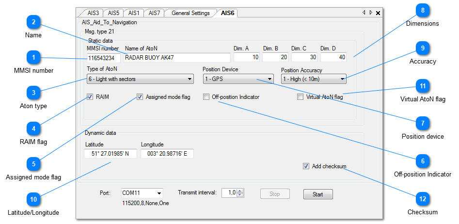
The AIS AtoN object will transmit AIS Message Type 21.

 
AtoN


Operation

 
After clicking the "Start" button the AIS simulation will start, and the messages will be sent to the selected output port of the PC, until the "Stop" button is pressed. Note that only those messages will be sent that are checked.
 
All messages are shown in the I/O Port Monitor as they are output. When logging is ON (toolbar option), the sentences will also be written to the user selected log file.
 
Clicking the "Stop" button will suspend the operation, until "Start" is clicked again.
 
When the Transmit Interval is set to 0.0 the sentences are output as "single shot" each time you click the "Start" button.
 
Clicking the little X top-right will exit the object and save optionally all current values, so that next time the target is opened it can continue where it stopped. Note: saving is an optional setting in the General Settings.
 
A short description of each field follows.
 
 
1

MMSI number

1. MMSI number
9-digit MMSI number.
Auto generated by NemaStudio when instantiating a new object.
Can be changed at will.
2

Name

2. Name
Name/description of AtoN
3

Aton type

3. Aton type
The nature and type of AtoN.
 
0 Default, Type of AtoN not specified
1 Reference point
2 RACON
3 Fixed structures off-shore, such as oil platforms, wind farms.
(NOTE 1 – This code should identify an obstruction that is fitted with an
AtoN AIS station)
4 Spare, Reserved for future use
Fixed AtoN:
5 Light, without sectors
6 Light, with sectors
7 Leading Light Front
8 Leading Light Rear
9 Beacon, Cardinal N
10 Beacon, Cardinal E
11 Beacon, Cardinal S
12 Beacon, Cardinal W
13 Beacon, Port hand
14 Beacon, Starboard hand
15 Beacon, Preferred Channel port hand
16 Beacon, Preferred Channel starboard hand
17 Beacon, Isolated danger
18 Beacon, Safe water
19 Beacon, Special mark
Floating AtoN:
20 Cardinal Mark N
21 Cardinal Mark E
22 Cardinal Mark S
23 Cardinal Mark W
24 Port hand Mark
25 Starboard hand Mark
26 Preferred Channel Port hand
27 Preferred Channel Starboard hand
28 Isolated danger
29 Safe Water
30 Special Mark
31 Light Vessel/LANBY/Rigs
4

RAIM flag

4. RAIM flag
RAIM flag: Receiver Autonomous Integrity Monitoring (RAIM) flag of electronic position fixing device
  • Unchecked = RAIM not in use
  • Checked = RAIM in use
 
5

Assigned mode flag

5. Assigned mode flag
Check if station operating in assigned mode
6

Off-position Indicator

6. Off-position Indicator
 
7

Position device

7. Position device
Type of electronic position device.
 
0 = undefined (default)
1 = GPS
2 = GLONASS
3 = combined GPS/GLONASS
4 = Loran-C
5 = Chayka
6 = integrated navigation system
7 = surveyed
8 = Galileo
9-15 = not used
8

Dimensions

8. Dimensions
Reference point for reported position; also indicates the dimension of an AtoN (m)
9

Accuracy

9. Accuracy
The position accuracy (PA) flag
  • 0=Low
  • 1=High
10

Latitude/Longitude

10. Latitude/Longitude
The position of the AtoN object. To change: place the mouse cursor left of the leftmost digit.
Then just start typing the latitude or longitude, the cursor will advance automatically and the value will be automatically formatted.
11

Virtual AtoN flag

11. Virtual AtoN flag
Check if virtual AtoN
12

Checksum

12. Checksum
Check this if you want a checksum added to each sentence.