Menu

Class A vessel


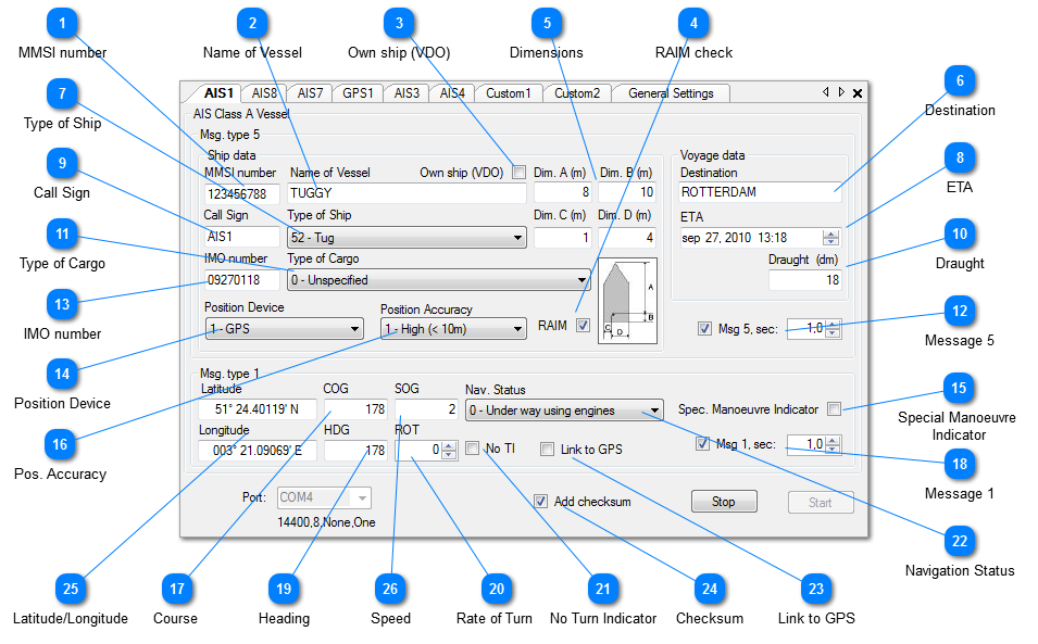
The AIS Class A vessel object will optionally transmit AIS Message Types 1 and 5.

 
Class A vessel
 

Operation

 
After clicking the "Start" button the AIS simulation will start, and the messages will be sent to the selected output port of the PC, until the "Stop" button is pressed. Note that only those messages will be sent that are checked.
 
All messages are shown in the I/O Port Monitor as they are output. When logging is ON (toolbar option), the sentences will also be written to the user selected log file.
 
Clicking the "Stop" button will suspend the operation, until "Start" is clicked again.
 
When the Transmit Interval is set to 0.0 the sentences are output as "single shot" each time you click the "Start" button.
 
Clicking the little X top-right will exit the object and save optionally all current values, so that next time the target is opened it can continue where it stopped. Note: saving is an optional setting in the General Settings.
 
A short description of each field follows.
 
1

MMSI number

1. MMSI number
9-digit MMSI number.
Auto generated by NemaStudio when instantiating a new object.
Can be changed at will.
2

Name of Vessel

2. Name of Vessel
Max. 20 characters, name of vessel
 
3

Own ship (VDO)

3. Own ship (VDO)
Own ship indicator.
Check this box for sending !AIVDO instead of !AIVDM by this object.
Note that only one active AIS target can be defined as "own ship"
 
4

RAIM check

4. RAIM check
 
5

Dimensions

5. Dimensions
Dim A, Dim B, Dim C, Dim D
Reference point for reported position (see figure). Also indicates the dimension of the vessel (m).
Image shows how dimension values are interpreted.
 
 
6

Destination

6. Destination
Destination of vessel. Max 20 characters.
7

Type of Ship

7. Type of Ship
0 = not available
1-99 as defined in ITU-R M1371
 
8

ETA

8. ETA
EStimated time of arrival.
 
9

Call Sign

9. Call Sign
Max 7 characters call sign.
Will be initialized by NemaStudio with the object identifier.
 
10

Draught

10. Draught
Maximum present static draught in 1/10 meters (dm)
 
11

Type of Cargo

11. Type of Cargo
0 = not available
1-9 as defined in ITU-R M1371
 
12

Message 5

12. Message 5
Check this box if you want NemaStudio to send AIS message type 5 (voyage data)
and the interval in seconds this message must be sent
13

IMO number

13. IMO number
International Maritime Organization number: 1-999999999; 0 = not available
 
14

Position Device

14. Position Device
Type of electronic position device.
 
0 = undefined (default)
1 = GPS
2 = GLONASS
3 = combined GPS/GLONASS
4 = Loran-C
5 = Chayka
6 = integrated navigation system
7 = surveyed
8 = Galileo
9-15 = not used
 
15

Special Manoeuvre

Indicator

15. Special Manoeuvre 
Indicator
This is a three-state checkbox:
  • Unchecked = 0 = not available
  • Filled = 1 = not engaged in special manoeuvre
  • Checked = 2 = engaged in special manoeuvre
 
16

Pos. Accuracy

16. Pos. Accuracy
The position accuracy (PA) flag
  • 0=Low
  • 1=High
17

Course

17. Course
Course over ground in degrees
18

Message 1

18. Message 1
Check this box if you want NemaStudio to send AIS message type 1
and the interval in seconds this message must be sent
19

Heading

19. Heading
True heading in degrees (0-359)
 
20

Rate of Turn

20. Rate of Turn
The ROT control gives the actual Rate Of Turn in degrees/min. The actual ROT in deg/min is converted to the ROTais value (+/- 126) and stored in the ROT field in message 1. When the "No TI"(no Turn Information) checkbox is checked the ROTais value -128 is stored in the ROT field in message 1.
When the value in the ROT up/down control > 708 or < -708 then the ROT ais value is set to 127 or -127.
 
21

No Turn Indicator

21. No Turn Indicator
When checked the ROTais value -128 is stored in the ROT field in message 1,
indicating that there is no turning indicator present.
The ROT control will also be greyed out when this box is checked.
 
22

Navigation Status

22. Navigation Status
Select a navigation status:
0 = under way using engine
1 = at anchor
2 = not under command
3 = restricted maneuverability
4 = constrained by her draught
5 = moored
6 = aground
7 = engaged in fishing
8 = under way sailing
9 = reserved for future amendment of navigational status
10 = reserved for future amendment of navigational status
11-14 = reserved for future use
15 = not defined
 
23

Link to GPS

23. Link to GPS
Check this if you want to link this AIS target to any active GPS.
A dropdown selection box will open with all currently active GPS's.
Position, Course and Speed will be taken from the selected GPS.
 
24

Checksum

24. Checksum
Check this if you want a checksum added to each sentence
25

Latitude/Longitude

25. Latitude/Longitude
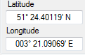
Current position of the vessel. To change the value the instrument must be stopped. To change: place the mouse cursor left of the leftmost digit. Then just start typing the latitude or longitude, the cursor will advance automatically and the value will be automatically formatted. During a simulation session the position will be continuously  updated to the newly calculated current position, taking course and speed into account. When a GPS is linked, the position is taken from the GPS.
 
26

Speed

26. Speed
Speed over ground