The AIS Class B vessel object will optionally transmit AIS Message Types 14, 18, 19 and 24.
Operation
After clicking the "Start" button the AIS simulation will start, and the messages will be sent to the selected output port of the PC, until the "Stop" button is pressed. Note that only those messages will be sent that are checked.
All messages are shown in the I/O Port Monitor as they are output. When logging is ON (toolbar option), the sentences will also be written to the user selected log file.
Clicking the "Stop" button will suspend the operation, until "Start" is clicked again.
When the Transmit Interval is set to 0.0 the sentences are output as "single shot" each time you click the "Start" button.
Clicking the little X top-right will exit the object and save optionally all current values, so that next time the target is opened it can continue where it stopped. Note: saving is an optional setting in the
General Settings.
A short description of each field follows.
 MMSI number
9-digit MMSI number
|
|
 Vessel name
Name of vessel, max 20 characters
|
|
 Own ship (VDO)
Check this if own ship.
The VDO instead of VDM formatter will be used in the AIS sentences.
|
|
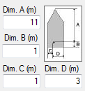
 Dimensions
Dim A, Dim B, Dim C, Dim D
Reference point for reported position (see figure). Also indicates the dimension of the vessel (m).
Image shows how dimension values are interpreted.
|
|
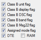
 Flags
-
Class B flags, see ITU-R M.1371 for Message 18
-
Assigned mode flag
-
DTE flag
-
RAIM flag: Receiver Autonomous Integrity Monitoring (RAIM) flag of electronic position fixing device
-
Unchecked = RAIM not in use
-
Checked = RAIM in use
|
|
 Type of Ship
0 = not available
1-99 as defined in ITU-R M1371
|
|
 Call Sign
Max 7 characters call sign.
Will be initialized by NemaStudio with the object identifier.
|
|
 Vendor identifier
Unique Vendor Identifier
|
|
 Type of Cargo
0 = not available
1-9 as defined in ITU-R M1371
|
|
 Position Device
Type of electronic position device.
0 = undefined (default)
1 = GPS
2 = GLONASS
3 = combined GPS/GLONASS
4 = Loran-C
5 = Chayka
6 = integrated navigation system
7 = surveyed
8 = Galileo
9-15 = not used
|
|
 Message 14
Check this box if you want NemaStudio to send AIS message type 14 (Safety Related Message)
and the interval in seconds this message must be sent
|
|
 Safety message
|
|
 Position Accuracy
The position accuracy (PA) flag
|
|
 Course
 over ground in degrees
|
|
 Message 18
Check this box if you want NemaStudio to send AIS message type 18 (Standard Class B CS Position Report)
and the interval in seconds this message must be sent
|
|
 Heading
True heading in degrees (0-359)
|
|
 Link to GPS option
Check this if you want to link this AIS target to any active GPS.
A dropdown selection box will open with all currently active GPS's.
Position, Course and Speed will be taken from the selected GPS.
|
|
 GPS to link
A dropdown selection box will open with all currently active GPS's when the Link to GPS option is checked
|
|
 Checksum
Check this if you want a checksum added to each sentence
|
|
 Message 24
Check this box if you want NemaStudio to send AIS message type 24 (Class B CS Static Data Report)
and the interval in seconds this message must be sent
|
|
 Message 19
Check this box if you want NemaStudio to send AIS message type 19 (Extended Class B Equipment Position Report)
and the interval in seconds this message must be sent
|
|
 Speed
Speed over Ground
|
|
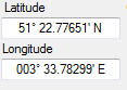
 Latitude/Longitude
Current position of the vessel. To change the value the instrument must be stopped. To change: place the mouse cursor left of the leftmost digit. Then just start typing the latitude or longitude, the cursor will advance automatically and the value will be automatically formatted. During a simulation session the position will be contineously updated to the newly calculated current position, taking course and speed into account. When a GPS is linked, the position is taken from the GPS.
|
|